Birdwatching routes
Corta Alloza wetland route


RECOMMENDATIONS
 The welfare of the animals must come before all other considerations of any observer, amateur or professional.
- Avoid disturbing the birds, especially during the breeding season.
- Do not destroy or alter their habitat to obtain a better observation or photograph.
- Avoid scaring away incubating adults, as this could ruin the chance of a successful hatching of chicks. Do not manipulate nests with eggs or chicks.
- Wildlife observation or photography is an essential tool for inspiring the protection of wildlife.
Singular Wetland of Corta Alloza
Located between the old underground mines Innominada and La Oportuna, we find what is considered today a good example of mining restoration. The final hole of Corta Alloza, 130m deep, was filled (1991-1998) with mining waste and waste from the industrial use of coal until reaching the original level of the land. On top of this filling an environmental restoration was carried out, recreating a wetland area, very rare in the region.
This wetland consists of two flood basins. The water level fluctuates according to the weather, so that during periods of heavy rainfall they join together to form a single lagoon. Over time this area has been colonised by vegetation and fauna. Today it is an ecosystem of great ecological value, included in the Inventory of Singular Wetlands of Aragon.
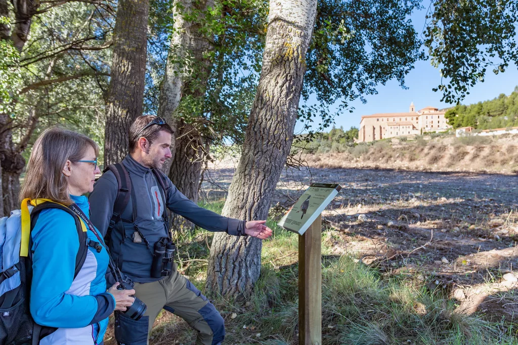
The route starts next to the old mining track that connects the towns of Andorra and Alloza. The paved road leads to an old workshop building. The recently installed observation screen allows you to look out over the first of the basins.
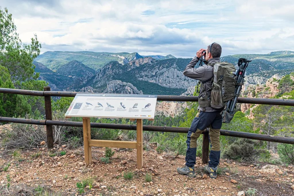
The path runs along the second basin, and as it runs through the pasture, it leads to a raised viewing point that allows a general view of the wetland. Marsh Harrier, Coot, Mallard and, with luck, Pochard are to be seen here.
After a short slope, the path runs along a wide track, without losing altitude, in a drier environment and close to the pine forest, where you can discover the tracks of some of the mammals that inhabit this restored space.
After descending next to one of the irrigation ditches that collect the runoff water from the basin, you ascend to a second viewing point, and take the path that leads back to the starting point.
Birds that can be found on the route:
Water birds: Mallard, Little Grebe, Pochard, Eurasian Coot, Eurasian Moorhen, Marsh Harrier, Grey Heron, Little Ringed Plover, White Wagtail.
Forest and agricultural areas birds: Corn Bunting, Sardinian Warbler, Black Redstart, Stonechat, European Goldfinch, Common Chaffinch, Blackcap, Great Tit, Thekla Lark, Eurasian Skylark, Black-eared Wheatear and Woodlark.

MIDE
Duration: 45 min
Height gained (+): 50 m
Height lost (-): 50 m
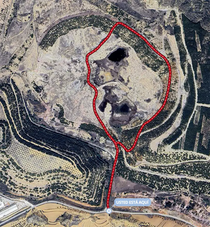
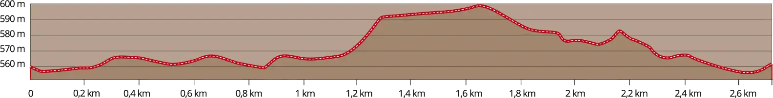
Distance: 2,7 km
Type of route: Circular
Harshness of the environment: 2
Finding your way: 2
Difficulty underfoot: 2
Effort needed: 1
* Summer conditions, no snow, timings according to MIDE criteria, without stops over the whole route.
Singular Wetland of Corta Alloza
Located between the old underground mines Innominada and La Oportuna, we find what is considered today a good example of mining restoration. The final hole of Corta Alloza, 130m deep, was filled (1991-1998) with mining waste and waste from the industrial use of coal until reaching the original level of the land. On top of this filling an environmental restoration was carried out, recreating a wetland area, very rare in the region.
This wetland consists of two flood basins. The water level fluctuates according to the weather, so that during periods of heavy rainfall they join together to form a single lagoon. Over time this area has been colonised by vegetation and fauna. Today it is an ecosystem of great ecological value, included in the Inventory of Singular Wetlands of Aragon.
The route starts next to the old mining track that connects the towns of Andorra and Alloza. The paved road leads to an old workshop building. The recently installed observation screen allows you to look out over the first of the basins.
The path runs along the second basin, and as it runs through the pasture, it leads to a raised viewing point that allows a general view of the wetland. Marsh Harrier, Coot, Mallard and, with luck, Pochard are to be seen here.
After a short slope, the path runs along a wide track, without losing altitude, in a drier environment and close to the pine forest, where you can discover the tracks of some of the mammals that inhabit this restored space.
After descending next to one of the irrigation ditches that collect the runoff water from the basin, you ascend to a second viewing point, and take the path that leads back to the starting point.
Birds that can be found on the route:
Water birds: Mallard, Little Grebe, Pochard, Eurasian Coot, Eurasian Moorhen, Marsh Harrier, Grey Heron, Little Ringed Plover, White Wagtail.
Forest and agricultural areas birds: Corn Bunting, Sardinian Warbler, Black Redstart, Stonechat, European Goldfinch, Common Chaffinch, Blackcap, Great Tit, Thekla Lark, Eurasian Skylark, Black-eared Wheatear and Woodlark.
MIDE
Duration: 45 min
Height gained (+): 50 m
Height lost (-): 50 m
Distance: 2,7 km
Type of route: Circular
Harshness of the environment: 2
Finding your way: 2
Difficulty underfoot: 2
Effort needed: 1
* Summer conditions, no snow, timings according to MIDE criteria, without stops over the whole route.
RECOMMENDATIONS
- The welfare of the animals must come before all other considerations of any observer, amateur or professional.
- Avoid disturbing the birds, especially during the breeding season.
- Do not destroy or alter their habitat to obtain a better observation or photograph.
- Avoid scaring away incubating adults, as this could ruin the chance of a successful hatching of chicks. Do not manipulate nests with eggs or chicks.
- Wildlife observation or photography is an essential tool for inspiring the protection of wildlife.